Flowed Land

Flowed Land was created in the mid-nineteenth century by the owners of the McIntyre Iron Works in an effort to channel more water past their blast furnaces. A dam was erected on the Opalescent River below Lake Colden, causing most if not all of the Opalescent's flow to be diverted down Calamity Brook (see the link above for information regarding the calamity of Calamity Brook). This Brook meets the Hudson just below Lake Henderson, and just above the MacIntyre's furnaces. The dam on the Opalescent was damaged by a 1979 flood, and partially breached in 1984 by the NYS Department of Environmental Conservation due to safety concerns. There have been rumors circulating that the dam may be rebuilt to restore Flowed Land to half its original level; however, the High Peaks Unit Management Plan recommends that no action be taken to restore the dam.

View from Mt. Colden. Lake Colden is in the foreground, and Flowed
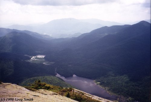
Land is behind and to the left of Lake Colden. The Opalescent flows out of the
lefthand side of Flowed Land. Through the valley beyond Flowed Land winds Calamity
Brook on its way towards the Hudson just above the McIntyre Iron Works.
The high peaks at the end of this valley are the Santanonis
(Santanoni Peak, the tallest in this range, is also the tallest mountain in
New York west of the Hudson). Just in front of the left end of the Santanoni
Range, Lake Henderson is visible as a faint white spot in this photograph.


The remnants of the Flowed Land dam.
I do apologize for how dark this photo appears.


View of Mt. Colden across Flowed Land.

< Previous: Constable Pond | Main Lakes page | Next: Fourth Lake >