Contrary to popular belief, the Adirondacks are not geologically related to
the Appalachians. In fact, they are the only mountains in the eastern U.S.
that aren't geologically Appalachian. They actually belong to a much
older formation known to some as the Canadian Shield, as the Laurentian
Shield to others, and as the Precambrian Shield to the rest. This is a huge
formation, underlying about half of Canada (it was noted that Canadians more
often refer to it as the Canadian Shield, while Americans prefer Precambrian
Shield). The formation extends down through the Thousand Islands region of
the St. Lawrence River Valley and into the Adirondacks. Adirondack rocks are
most closely related to rocks found in what is known as the Grenville
Province, an ancient formation north of Lake Ontario and east of Lake Huron.
As a whole, the rocks making up the Adirondack region are amongst the oldest
on the planet, around one billion years old. For the Adirondack bedrock to
consist of the minerals that it does, it must have formed underneath 15
miles of overlying rock. Sediment building up on the bottom of an
ancient sea, covering the present-day eastern seaboard, was forced lower and
lower by more and more sediment, until it finally metamorphosed under the
intense heat and pressure into the rocks we see today, a billion years
later. After repeated uplifts spanning hundreds of millions of years,
including one that is continuing today at a rate of 2 to 3 millimeters per
year, and constant erosion of the sedimentary layer above, the ancient
bedrock finally reached the surface. The rock that makes up most of the High
Peaks region is Anorthosite. This rock, more often found well underground
than at the Earth's surface, apparently is very common on the moon. The
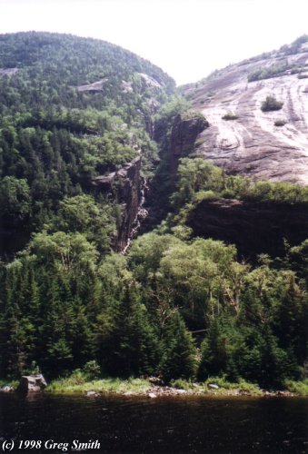
photo to the right shows the Trap Dike on Mt.
Colden. This giant cleft, which runs nearly to the summit of the
mountain (and, incidentally, is a possible climbing route from Avalanche Lake), was formed by
the erosion of the softer gabbro that had intruded into the anorthosite
bedrock. It is conceivable that the dike will only get deeper, judging by
the large volume of water that, although hard to see here, was flowing
through it at the time this photo was taken. The rest of the Adirondacks
are made up of various different rocks, mostly some form of gneisse.
Another common misconception is that the Adirondacks are just old,
worn-down peaks like the Appalachian chain. Yes, it is true that at one
point Upstate New York was at an elevation rivaling, if not exceeding, that
of the Himalayas today. However, most of the major features of the landscape
that you see today are a result of the last Ice Age, 10,000 years or so ago,
and the most recent uplift of the region, which probably began about 5 to 10
million years ago. The huge boulders often seen lying around the
Adirondacks, sometimes in places you wouldn't expect to see them (such as
the summit of Mt. Marcy or in an otherwise
rock-free meadow), are by-products of the glaciers. Known as erratics, they
are picked up by the moving ice sheet and dropped when the glacier receded.
Since the mile-high summit of Marcy was itself covered by ice a mile thick,
it was no more immune to receiving an erratic than a valley 4,000 feet
lower. [As a side note, before there was widespread acceptance of
glaciers and the Ice Ages, a popular explanation for these erratics was that
a vast ocean covered these lands, and the boulders just floated to where
they are now. Personally, I am more inclined to believe in two-mile thick
sheets of ice than I am in a 15-ton boulder floating to the 5,344-foot
summit of Mt. Marcy.] Erosion continues, exposing more and more bedrock.
Major new slides form on the flanks of the taller peaks rather frequently,
sweeping away large patches of soil and vegetation. Another major
geological/geographical feature caused by the uplift of the region is the
many fault lines throughout the Adirondacks. A simple glance at a
topographical map will show that these faults, for the most part, all lie in
a northeast-southwest orientation. Long Lake and Indian Lake, about 15
miles apart as the crow flies, run nearly parallel to each other. Nearly all
the passes and valleys in the High Peaks run in the same general direction:
Indian Pass, Avalanche Pass, Lake Arnold Pass, the Johns Brook Valley, the
Ausable Valley, Hunters Pass. These valleys, lakes, and passes exist where
faults weakened the bedrock, allowing it to be more easily eroded by
glaciers.